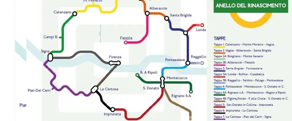
Tappe Anello del Rinascimento

The Renaissance Ring - Anello del Rinascimento

The Metropolitan City of Florence
By walk & by bike

The Ring of the Renaissance (in Italian Anello del Rinascimento) is an amazing route to be taken on foot or by bicycle, a unique historical-artistic itinerary designed to unite the treasures of Renaissance art and culture with the extraordinary Tuscan landscape, leading walkers through those villages and towns that, as satellites of Florence, did not fail to feel the cultural and innovative thrust that came from the capital of the Medici family.

In all probability, there would not have been the various Della Mirandola, Poliziano, Michelangelo, Botticelli, Pollaiolo, Verrocchio and da Sangallo, had there not been an enlightened and munificent lord behind them. The Renaissance is not exclusive to the Tuscan capital but also developed thanks to and in the territory.

This long preamble is intended to make it clear that the Renaissance Ring, an outdoor route, is not only an excursion to discover unusual landscapes and evocative nature, but is also a new way to reacquaint oneself with the historical and artistic aspects of the Renaissance that gravitate around what happens to be the epicentre of the route: the Dome of Florence Cathedral, symbol of the city.

The Renaissance Ring is a long-distance itinerary on paths and provincial roads. It crosses extremely diverse landscapes, from the hills to the plains, from the rivers to the Apennine mountains.
It covers and includes all the municipalities in the Florence Area, and consists of a main ring (8 stages for approx. 130 km) to which are added 5 variants and 3 additions, for a total of 250 km, which can be broken up into modules.

On this website in the Download section you can find a map of the hiking path

You can find a digital map with route indications for bike hikers.


Photo credit

Comune di Firenze

Quick info
Travel length
250.00km
Municipalities
Bagno a Ripoli
Calenzano
Campi Bisenzio
Fiesole
Figline e Incisa Valdarno
Firenze
Impruneta
Lastra a Signa
Londa
Pelago
Pontassieve
Reggello
Rignano sull’Arno
Rufina
Scandicci
Sesto Fiorentino
Signa
Vaglia
Stages

Stages

STAGE 1: CALENZANO - VAGLIA

The first trail begins in Calenzano and ends in Vaglia. It is quite fascinating for its natural beauty, especially in the vicinities of Monte Morello (19.7 km / 6.40hrs).
Piazza Vittorio Veneto, 50041 Calenzano FI, Italia

STAGE 2: VAGLIA - FIESOLE

The second stage starts from Vaglia, passes through Alberaccio and finally reaches Fiesole, with beautiful views over Florence and Fiesole (23 km/6.40hrs). Taking the "variant" Vaglia-Alberaccio-Santa Brigida, pilgrims will get to the Montesenario Monastery, the Madonna del Sasso Sanctuary, and Poggio Ripaghera, where it is possible to admire endemic botanic species (17,5 km/ 3hrs). In alternative, the Montesenario Monastery "variant" follows the CAI 00 path, leading walkers to both the convent and its famous Ghiacciaia di Montesenario.
Vaglia FI

STAGE 2A: BIVIGLIANO- MONTE SENARIO

This trail is 1,3 km long with a difference in altitude of 170 mt.
Monte Senario

VARIANT 2B: ALBERACCIO - FIESOLE

This trail plunges into the countryside; 10,7 km.
Alberaccio

STAGE 3: SANTA BRIGIDA - PONTASSIEVE

Resuming the main “ring” path, the third stage goes from Santa Brigida to Pontassieve (13 km/4hrs), through the incomparable, regenerating, Tuscan countryside, with its farmhouses, vineyards and mills.
Santa Brigida

VARIANT 3A: LONDA- RUFINA

A 13 km long trail with a difference in altitude of 800 mt.
Londa

VARIANT 3B: RUFINA - CASABELLA

Short stage
Rufina

VARIANT 3C: REGGELLO -PELAGO

Challenging stage, 24,7 km long, with a difference in altitude of 1200 mt.
Abbazia di Vallombrosa

VARIANT 3D: PELAGO - PONTASSIEVE

Short stage (8,3 km)
ponte mediceo San Francesco

STAGE 4: PONTASSIEVE - SAN DONATO

This trail starts in Pontassieve, skirts Montecucco and reaches San Donato (12 km/4,30hrs), with Valdarno valley as its main focus. From Rignano sull’Arno, hikers will walk the trail leading to Bagno a Ripoli, passing through Montecucco (13.5 km/4hrs). In the past, this was the path treaded by pilgrims on their way to Rome.
Pontassieve

VARIANT 4A: RIGNANO SULL'ARNO - BAGNO A RIPOLI

This stage is 15,8 km long and crosses the Montecucco area.
Montecucco, san Donato

VARIANT 4B: FIGLINE INCISA - SAN DONATO IN COLLINA

It’s a demanding stage of 25,5 km; the path enters the Chianti region and has a difference in altitude of 1300 mt.
Figline Incisa

STAGE 5: SAN DONATO IN COLLINA - IMPRUNETA

The trail leading from San Donato in Collina to Impruneta (18 km/6hrs) is famous for woods (Fonte Santa), vineyards and olive trees dotting the green landscape of the hills.
SAN DONATO IN COLLINA

STAGE 6: IMPRUNETA - LA CERTOSA

Leaving Impruneta, the trail will lead pilgrims to La Certosa, where hikers can’t miss the chance to visit the Certosa del Galluzzo monumental complex (7 km/2hrs).
impruneta

STAGE 7: CERTOSA - SIGNA

This long stage, La Certosa-Pian dei Cerri-Lastra a Signa-Signa (23 km/6.30hrs), will lead walkers to the valley floor of Bottai, through the rolling hills on the border with the Chianti region, the woods of Roveta and the countryside “diving” into the River Arno.
SIGNA

VARIANT 7A: LA CERTOSA - FIRENZE

From La Certosa reach Piazzale Michelangelo and enjoy a beautiful view over Florence (6 km/2hrs).
La Certosa di Firenze

STAGE 8: SIGNA - CALENZANO

The Signa-Campi Bisenzio-Calenzano trail (15,5 km/4hrs) focuses entirely on the exploration of Florence’s plane.
Campi Bisenzio

STAGE 8A SIGNA - FIRENZE

This stage, Signa-Florence (12,6 km/3hrs), takes hikers through Renai Park and Cascine Park.
PARCO DEI RENAI