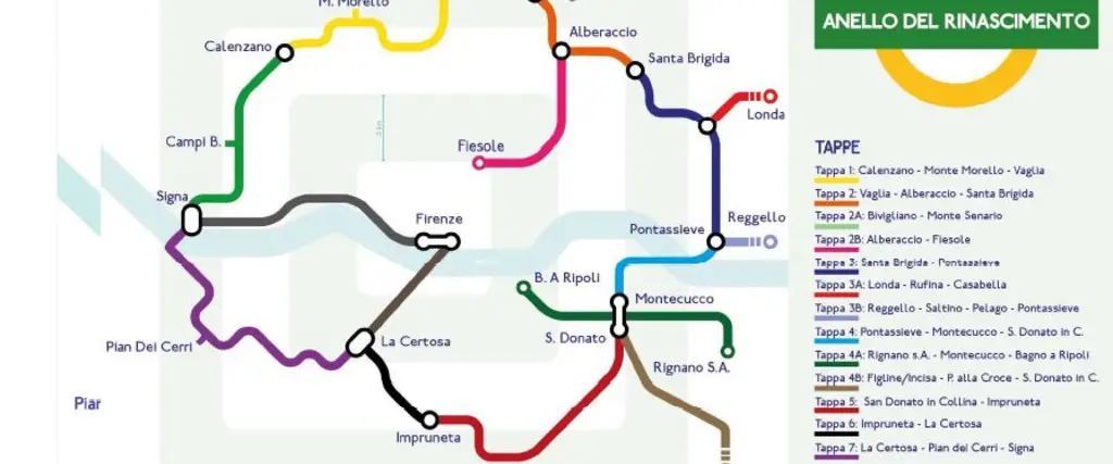
Tappe Anello del Rinascimento

The Renaissance Ring - Anello del Rinascimento

The Ring of the Renaissance (in Italian Anello del Rinascimento) is an amazing route to be taken on foot or by bicycle, a unique historical-artistic itinerary designed to unite the treasures of Renaissance art and culture with the extraordinary Tuscan landscape, leading walkers through those villages and towns that, as satellites of Florence, did not fail to feel the cultural and innovative thrust that came from the capital of the Medici family.

In all probability, there would not have been the various Della Mirandola, Poliziano, Michelangelo, Botticelli, Pollaiolo, Verrocchio and da Sangallo, had there not been an enlightened and munificent lord behind them. The Renaissance is not exclusive to the Tuscan capital but also developed thanks to and in the territory.

This long preamble is intended to make it clear that the Renaissance Ring, an outdoor route, is not only an excursion to discover unusual landscapes and evocative nature, but is also a new way to reacquaint oneself with the historical and artistic aspects of the Renaissance that gravitate around what happens to be the epicentre of the route: the Dome of Florence Cathedral, symbol of the city.

The Renaissance Ring is a long-distance itinerary on paths and provincial roads. It crosses extremely diverse landscapes, from the hills to the plains, from the rivers to the Apennine mountains.
It covers and includes all the municipalities in the Florence Area, and consists of a main ring (8 stages for approx. 130 km) to which are added 5 variants and 3 additions, for a total of 250 km, which can be broken up into modules.

On this website in the Download section you can find a map of the hiking path

You can find a digital map with route indications for bike hikers.


Photo credits: Comune di Firenze
Walking route
Bike route
Hiking route
Piazza Vittorio Veneto, 50041 Calenzano FI, Italia22394
Vaglia FI22394
Monte Senario22394
Alberaccio22394
Santa Brigida22394
Londa22394
Rufina22394
Abbazia di Vallombrosa22394
ponte mediceo San Francesco22394
Pontassieve22394
Montecucco, san Donato22394
Figline Incisa22394
SAN DONATO IN COLLINA22394
impruneta22394
SIGNA22394
La Certosa di Firenze22394
Campi Bisenzio22394
PARCO DEI RENAI22394
Details
Comune
City:
Bagno a Ripoli  Calenzano  Campi Bisenzio  Fiesole  Figline e Incisa Valdarno  Firenze  Impruneta  Lastra a Signa  Londa  Pelago  Pontassieve  Reggello  Rignano sull’Arno  Rufina  Scandicci  Sesto Fiorentino  Signa  Vaglia 
Distance
Distance:
250.00 km
Tipo gestione
Management:
general 
Accessibilita
Accessibility:  partially accessible

This hiking path is not entirely accessible

Points of interest